Rothaarsteig theme trail - Meiler, Wallen, Wüstungen

#deinsauerland / Neusta Touren / Rothaarsteig theme trail - Meiler, Wallen, Wüstungen
Do you actually know field terraces, trace bundles or pile slabs and would you recognize them?


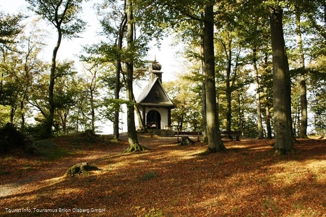
Borberg Kapelle

Tour starting point:

Brilon marketplace

Tour destination point:

Brilon marketplace

Properties:

  • Culturally interesting
  • Refreshment stop
  • Circular route

Additional Information

www.tourismus-brilon-olsberg.de

Category

Themenweg

Length

18.6 km

Duration

5:20 h

Elevation ascent

352 m

Elevation descent

345 m

Lowest point

427 m

Highest point

617 m

Condition

Difficulty

Recommended seasons

J F M A M J J A S O N D

Do you actually know field terraces, trace bundles or pile slabs and would you recognize them? Many such traces, also known as historical cultural landscape elements, can still be discovered along the Rothaarsteig. They tell us about how previous generations dealt with nature and the landscape and provide an insight into former social conditions and technologies. Together with the natural structures of the landscape, they contribute significantly to the special character and uniqueness of a landscape and provide a habitat for many endangered animals and plants. We invite you on a journey in the footsteps of our ancestors from times long past. The churchyard lies in the middle of a former medieval rampart, which has a triangular basic shape. One of the three castle gates has been reconstructed. The oldest ramparts probably date back to the time around the birth of Christ, when Germanic tribes defended themselves against the Celts advancing from the north. Excavations on the Borberg also uncovered the foundation wall of a church from the 13th/14th century. Today, the Borberg Chapel, which was built in 1925 in honor of Mary, Queen of Peace, is located at the highest point of the square.

Piles, Wallen, deserts - 1. a city is created


2352352

A town is born. The name "Brilon" was first mentioned in 973 AD.

Read More

Piles, Wallen, deserted areas - 2. arable town


Ackerbürgerstadt

Brilon, a farming town At the end of the 15th century, agriculture became increasingly important compared to trade and commerce.

Read More

Piles, Wallen, deserted areas - 4. Lindenallee


Lindenallee

Avenue of lime trees at the hospital The planting of streets with rows of trees has a long tradition.

Read More

Piles, Wallen, deserts - 5th ski jump


Sprungschanze

Ski jump With the construction of the railroad line from Hagen to Kassel (1873), more and more city dwellers from the Ruhrgebiet and the Rhineland came to Brilon to relax in the beautiful low mountain range landscape.

Read More

Piles, Wallen, deserted areas - 6. terraced fields


Terrassenflur

Terraced fields on the Poppenberg Terraced fields are traces of former arable farming.

Read More

Brilon Bürgerwald with Kyrill-Tor


Kyrill Tor

The Bürgerwald in Brilon with the mighty Kyrill-Tor is a reminder of the destructive force of the hurricane, but also of the reconstruction.

Read More

Piles, Wallen, deserted areas - 7. old trunk road


Fernstraße

To avoid the damp, swampy valleys, many paths in the Sauerland at that time ran over the mountains.

Read More

Piles, Wallen, deserted areas - 8. forest meadow valley


Waldwiesental

Without human intervention, the entire Sauerland would be a forest landscape except for the moors and rocky cliffs.

Read More

Piles, Wallen, deserted sites - 9. deserted site Hilbringh.


Wüstung Hilbringhusen

Deserted Hilbringhusen Again and again, crop failures, epidemics, famines and raids plagued the people in the Brilon area.

Read More

Piles, Wallen, deserted areas - 10. iron smelting


Eisenverhüttung

Iron smelting in the Hilbringse The origins of Brilon's ore mining and iron smelting probably date back to the pre-Roman Iron Age.

Read More

Piles, Wallen, deserted areas - 11.Landwehr


Landwehr

Landwehr are ramparts that served to protect and defend territories in the Middle Ages.

Read More

Piles, Wallen, deserted areas - 12th Wallen Papendiek


Wälle Papendiek

If the arable land on the fertile soils of the Brilon plateau did not yield enough, the so-called wild lands were created in the Heid.

Read More

Piles, Wallen, deserted areas - 13. deciduous forest


Laubwald

Deciduous forest on the Borberg

Read More

Piles, Wallen, deserted areas - 14th Borberg


Borberg

Borberg's churchyard Here you will find the ditches and ramparts of an early medieval hill fort from the 9th century.

Read More

Borberg's churchyard (Seelenort)


Kapelle Borberg

Sauerland-Seelenorte and scene of a 2.

Read More

Piles, Wallen, deserted areas - 15th pile


Meiler

Meiler am Borberg With a bit of luck, you can discover circular, flat areas in the Brilon forest.

Read More

Piles, Wallen, deserts - 16th St. Anthony


Hl Antonius

Wayside shrine of St. Anthony The origin of the wayside shrines can be traced back to the 13th century.

Read More

Free balloon emergency landing site 1968


Gedenkstein

Stone memorial to the emergency landing of a free balloon in 1968

Read More

Piles, Wallen, deserts - 17th breakfast place


Frühstücksplatz

This stone marks a resting place, the so-called breakfast place of the Brilon Schnade.

Read More

Piles, Wallen, deserted sites - 18th deserted site Hechlar


Wünstung Hechlar

Wüstung Hechlar The Hechlar farm was located in the bushes and spruce grove below the path.

Read More

Piles, Wallen, deserted areas - 19th Petersborn


Petersborn

Petersborn - Brilon's youngest district In 1954, the Petersborn district was built on an area of approx.

Read More

Piles, Wallen, deserted areas - 3. mining Drübel


Drübel

Mining on the Drübel The Drübel is one of the Kalkkuppen that protrude from the relatively flat plateau of the Brilon plateau around Brilon.

Read More

0 km 5 km 10 km 15 km 400 m 450 m 500 m 550 m 600 m 650 m 700 m 431 654

Information

Directions

Route: - Market square (459 m) - Ammertenbühl (473 m) - Poppenberg (580 m) - Petersborn (540 m) - Hiebammenhütte (513 m) - Borberg's Kirchhof (606 m) - St. Antonius (615 m) - Schustersknapp (595 m) - Petersborn (540 m) Sights: Altstadt Brilon, Borberg's KirchhofRefreshment stops: Hiebammenhütte, restaurants in Brilon

Equipment

Normal hiking equipment

Safety guidelines

No special instructions

Author Tip

If you don't want to walk the whole way, you can start from the Kyrill-Tor in the Petersborn district of Brilon, for example. The route is then only approx. 12 km long

Literature

Flyer with explanations, map section etc. from Brilon Wirtschaft und Tourismus GmbH

Maps

Download flyer: www.tourismus-brilon-olsberg.de

Public transit

By train to Brilon-Stadt stop, then 400 m walk to Brilon market square.

Take the bus to the Brilon-Markt stop.

How to get there

from the west:
A1 to Dortmund/Unna junction - then A44 to Werl junction - then
A445/A46 to Bestwig-Velmede junction and continue on the B7 to Brilon

from the north:
Hannover - A2 to Bielefeld junction - A33 to Wünnenberg-Haaren junction
and continue on the B480 to Brilon

from the east:
A44 Kassel to Wünnenberg-Haaren junction and continue on the B480 to Brilon or exit at Marsberg junction and continue on the B7 to Brilon

from the south:
to Kassel and continue on the A44 to Wünnenberg-Haaren junction or exit at Marsberg junction and continue on the B7 to Brilon
Parking

Paid parking is available directly around the Brilon market square. Otherwise free parking at the Kreishaus/police station.

Interesting places in the neighbourhood

Wir binden die Videos der Plattform “YouTube” des Anbieters Google LLC, 1600 Amphitheatre Parkway, Mountain View, CA 94043, USA, ein. Datenschutzerklärung: https://www.google.com/policies/privacy/, Opt-Out: https://adssettings.google.com/authenticated.