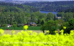
You can find a suggested hiking route here for a roughly 10-km loop starting and ending at Sorpesee.
Another hiking suggestion—a roughly 11-km hike taking about three hours around Buchholz and past the mountain hut—can be found here.
_______________________________________
Coordinates for your GPS (WGS 84):
GPS: N 51° 19' 53.1984 E 7° 58' 3.918
UTM: 32U 428085.87 5687189.61
________________________________________
The facility belongs to the Sauerland Rothaargebirge Nature Park Association (Naturpark Sauerland Rothaargebirge e.V.) and is maintained and cared for by the association.
However, if you notice any litter or damage, please notify us via email at info@npsr.de.
(Source: Naturpark Sauerland Rothaargebirge e.V.)